
Understanding Our Groundwater: The Gulf Coast Aquifer and Nueces County Conditions
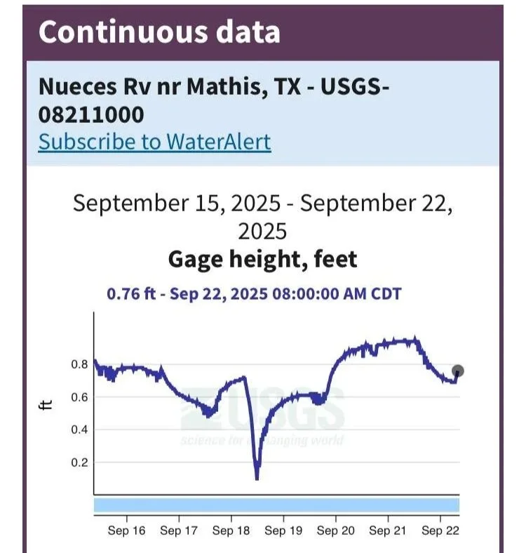
Source: U.S. Geological Survey (USGS Station 08211000 – Nueces River near Mathis, TX)
Observation Period: September 15–22, 2025
Gage Height: 0.76 feet (as of September 22, 2025, 8:00 AM CDT)
The Gulf Coast Aquifer — Explained in Plain Terms
The Gulf Coast Aquifer is the major underground water system running beneath coastal Texas — including Nueces County.
It’s made up of layered sand, silt, and clay formations called the Chicot, Evangeline, and Jasper. These layers store and move water underground, but the quality and amount of that water vary depending on depth and location.
In some areas, the aquifer contains fresh water, while in others it becomes brackish (slightly salty) or even saline near the coast.
Water Quality in Nueces County
Much of the groundwater here is naturally brackish or salty, due to ancient marine sediments, old salt domes, and coastal saltwater pushing inland when too much water is pumped.
Some wells also show higher mineral content, making treatment more difficult and costly.
The Texas Water Development Board (TWDB) has mapped these brackish zones for possible future use in desalination or blending projects.
How Much Can Be Pumped
The state limits groundwater withdrawals to maintain long-term aquifer health.
For Nueces County, the modeled Modeled Available Groundwater (MAG) is about 6,800–7,600 acre-feet per year through 2080 — relatively small compared to regional surface-water supplies.
Management Target (Desired Future Condition)
The regional goal is to ensure that average groundwater levels do not decline by more than 26 feet between 2010 and 2080.
The pumping limits above are calibrated to keep the Gulf Coast Aquifer within this sustainable range.
Risks of Over-Pumping
If groundwater use exceeds sustainable levels, several issues can occur:
Saltwater intrusion: salty water is drawn inland, contaminating wells.
Brine migration: deep saline water rises through faults or fractures.
Land subsidence: gradual sinking of land when clays dry out — less severe here than in Houston, but possible.
Declining well yields & higher costs: as salinity rises, treatment and maintenance become more expensive.
Local Context
The primary water supply for the Coastal Bend still comes from surface water — Choke Canyon Reservoir, Lake Corpus Christi, and the Mary Rhodes Pipeline.
Groundwater serves as a secondary backup source, but interest in brackish-water desalination is growing to improve supply reliability.
In Simple Terms
Nueces County groundwater is mostly brackish, limited in quantity, and sensitive to overuse.
Over-pumping can quickly worsen salinity and make wells harder or more expensive to use.
Responsible management — through local monitoring, clear limits, and conservation — keeps this vital resource sustainable for future generations.
References
U.S. Geological Survey (USGS): Real-Time Data for Texas – Station 08211000, Nueces River near Mathis, TX. https://waterdata.usgs.gov/tx/nwis/
Texas Water Development Board (TWDB): Groundwater Availability Models – Gulf Coast Aquifer System. https://www.twdb.texas.gov/groundwater/models/
Region N Water Planning Group: 2026 Draft Regional Water Plan – Coastal Bend Area.
Texas Commission on Environmental Quality (TCEQ): Groundwater Protection and Brackish Water Guidance. https://www.tceq.texas.gov/waterquality