
Water Quality Snapshot: Salinity and TDS at Hazel Bazemore Boat Ramp
📍 Nueces River – September 22, 2025
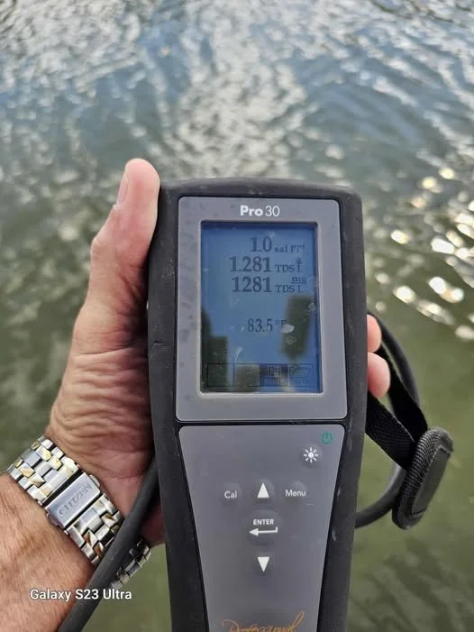
Instrument: YSI Pro30 Water Quality Meter
Location: Hazel Bazemore Boat Ramp, near Calallen
Readings (09/22/25):
Salinity: 1.0 parts per thousand (ppt)
Total Dissolved Solids (TDS): 1,281 mg/L
Temperature: 83.5°F
Field Update: Eastern Groundwater Field Status (September 22, 2025 – 12:30 PM)
As of 12:30 PM, it has been confirmed that all of the wells in the Eastern Groundwater Field are not currently pumping water into the Nueces River.
🔹 Status Details:
One well is down and has a service rig on-site.
Well Four, which normally discharges visibly through the fence line, shows no active flow at this time.
The cluster of six wells in the same field are not discharging to the outcrop; large-diameter piping is in place but inactive.
These observations were made during on-site review concurrent with the water quality sampling at Hazel Bazemore Park.
While it’s not uncommon for municipal or industrial wellfields to undergo maintenance or shutdown cycles, noting these conditions alongside field readings helps track potential connections between pumping activity and changes in local salinity, flow, and aquifer response.
What These Readings Show
1️⃣ Total Dissolved Solids (TDS)
TDS measures the combined minerals, salts, and metals in water.
Freshwater: <1,000 mg/L
Slightly brackish: 1,000–3,000 mg/L
Seawater: ~35,000 mg/L
At 1,281 mg/L, the Nueces River water at Hazel Bazemore was slightly brackish — higher than typical freshwater levels, indicating mild salt or mineral influence.
2️⃣ Salinity
Salinity at 1.0 ppt also reflects slightly brackish conditions.
These values are consistent with tidal influence, lower river flow, or reduced freshwater discharge, all of which can allow coastal saltwater to push further inland.
3️⃣ Temperature
Measured water temperature was 83.5°F, typical for late summer in South Texas.
Warm temperatures can increase evaporation rates, which concentrate dissolved salts in both surface and groundwater.
Why It Matters for Nueces County
Monitoring surface salinity and TDS helps identify saltwater intrusion trends in the lower Nueces Basin — a concern for both surface water management and groundwater protection.
Elevated salinity often indicates lower freshwater inflows or upstream pumping reductions.
Regular sampling near Hazel Bazemore Park helps correlate USGS gage data and field well activity with observed changes in water quality.
Tracking these metrics over time supports data-driven decisions under Texas Water Code Chapter 36 to preserve long-term aquifer health.
The Bigger Picture: Gulf Coast Aquifer Conditions
The Gulf Coast Aquifer, which underlies Nueces County, is made up of sand, silt, and clay layers (the Chicot, Evangeline, and Jasper).
Water quality in this aquifer varies — much of it is brackish due to natural salts, coastal influence, and historical geology.
State data shows the local Modeled Available Groundwater (MAG) is limited to roughly 6,800–7,600 acre-feet per year through 2080, with a Desired Future Condition (DFC) of no more than 26 feet of drawdown.
Overpumping could increase salinity risks through saltwater intrusion, brine migration, or declining well yields.
In Simple Terms
As of September 22, 2025, no wells in the Eastern Groundwater Field were discharging into the Nueces River, and slightly brackish water (1.0 ppt salinity, 1,281 mg/L TDS) was measured at Hazel Bazemore Park.
These observations help track how surface conditions, pumping activity, and aquifer dynamics interact — a key part of protecting water quality in the lower Nueces Basin.
References
U.S. Geological Survey (USGS): Real-Time Gage Data – Nueces River near Mathis (08211000)
https://waterdata.usgs.gov/tx/nwis/Texas Water Development Board (TWDB): Gulf Coast Aquifer Brackish Mapping Reports
https://www.twdb.texas.gov/groundwater/Texas Commission on Environmental Quality (TCEQ): Water Quality Standards and Groundwater Protection Guidance
https://www.tceq.texas.gov/waterqualityNueces Groundwater Field Site Observations: Field Verification – September 22, 2025, 12:30 PM CDT